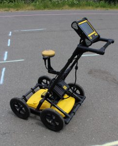
We use the LMX200™ Ground Penetrating Radar as one of our main tools. Manufactured by Sensors & Software, the unit provides more than a view underground.
Geo-Referenced Output
We can display your location and targets in Google Earth™ and other similar geo-referenced platforms. We can also produce data that will easily integrate utility locations into CAD drawings and GIS databases.
Map View On-Site Display
Using the optional external GPS, identified targets are displayed on the screen in real-time in a plan map view.
Field Interpretations
We can classify targets in real time and use the touchscreen to colour-code each target as it is located.
3D Depth Slicing
At complex sites, depth slicing reveals the orientation of pipes and cables at different depths and outlines the extent of vaults, foundations and buried tanks.
Contact us today to find out how you can use this state-of-the-art technology for your project!